


Planning a Bikepacking Trip to Big Sur
Everything I've learned about bikepacking in Big Sur, California

I love planning bikepacking trips. Especially to places where there isn’t a well-established bikepacking route. I have to turn into a bit of a detective or investigative journalist. A “bikepacking detective” you might say.
I sift through pages of Google search results, comb through old forum threads, evaluate Strava and RideWithGPS heat maps, and check out satellite imagery. I call the parks in the area and chat with park rangers. Sometimes the local bike shops or clubs have tips, too. This type of work gets me in a flow state like nothing else. I feel like I’m conjuring a brand new adventure that’s never been experienced.
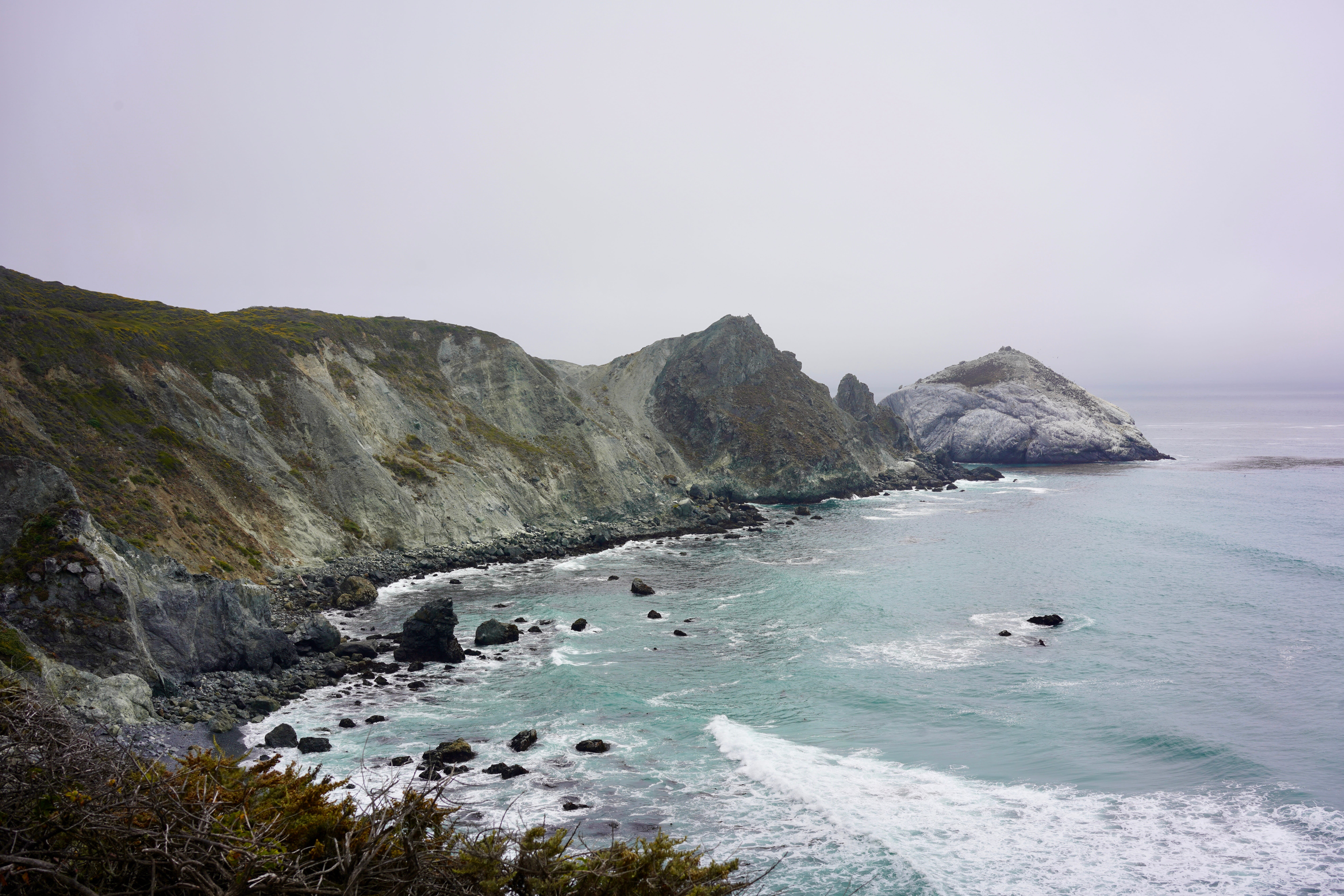
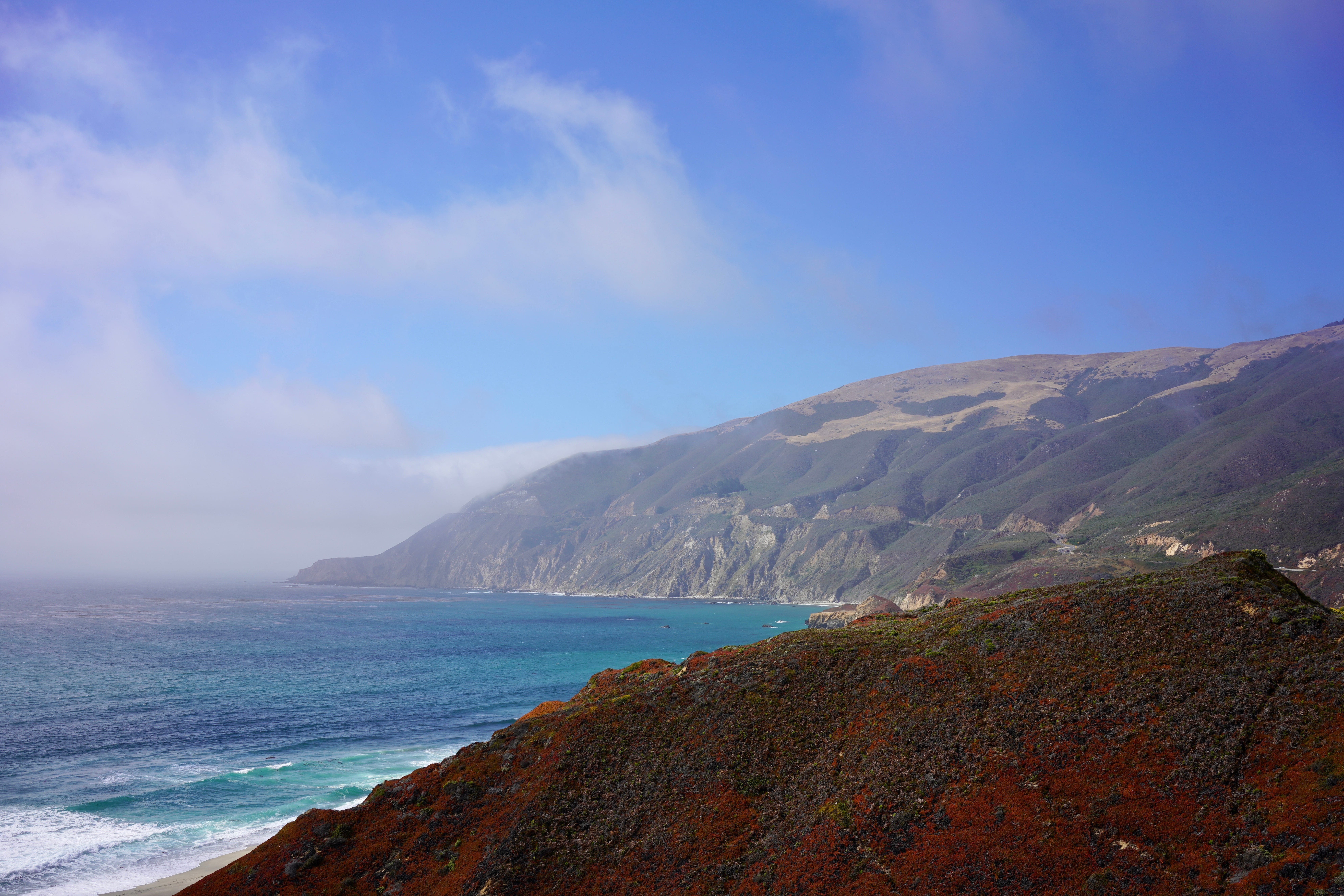
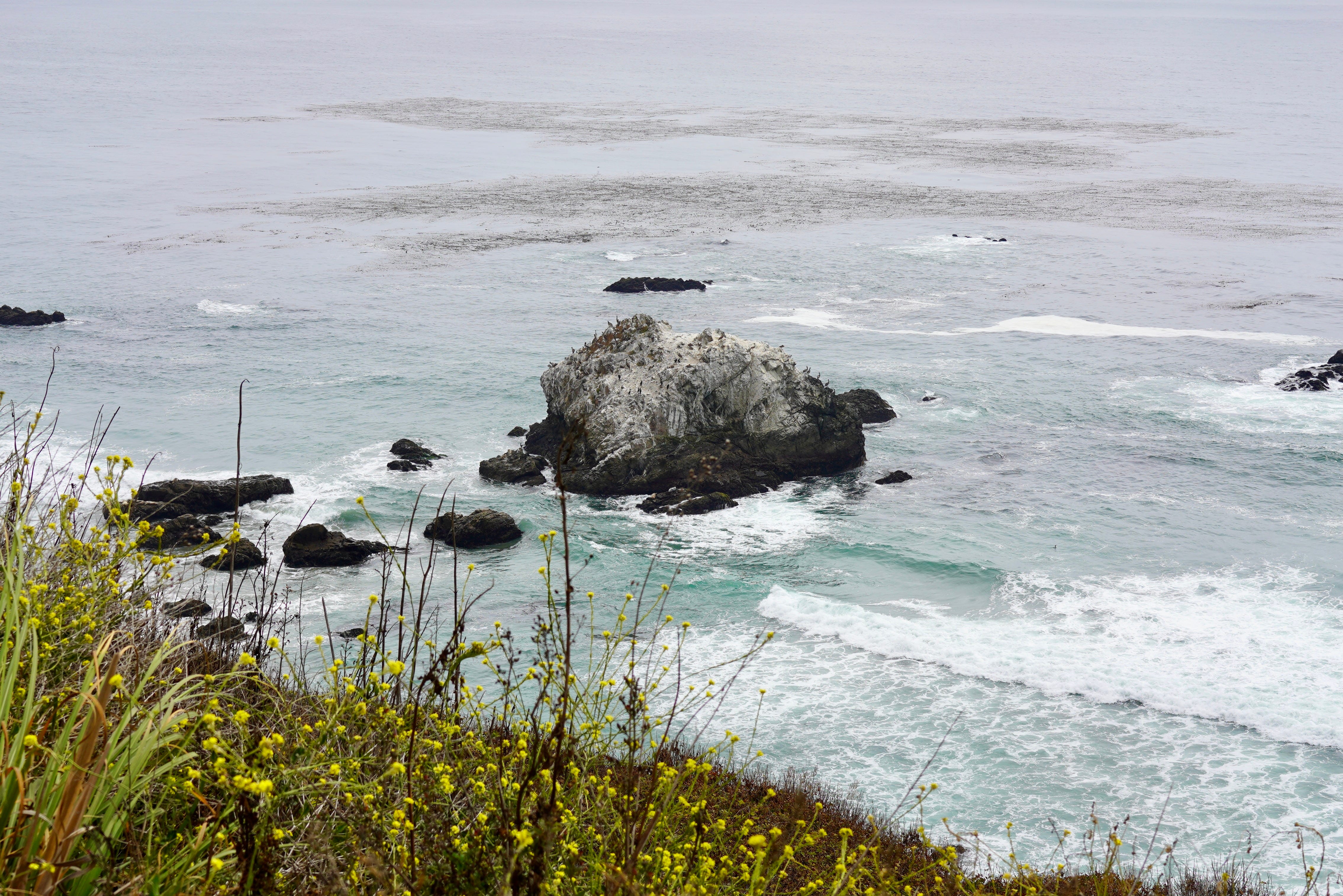
When I started thinking about where around San Francisco I’d like to go bikepacking, Big Sur was a clear contender. It’s is known for it’s rugged mountains, tall coastal cliffs, redwood forests, and one of the most beautiful undeveloped coastlines in the world. Big Sur gets about as many visitors per year as Yosemite National Park!
Route 1, also known as the Pacific Coast Highway, meanders along this coastline and is a renown cycling destination. However, it’s a highway so it’s shared with cars. And people driving giant RVs they’ve just rented and are now navigating the twists and turns at worrying speeds while trying to take in the sights of Big Sur. I’m not opposed to cycling Route 1, but I wanted to explore the off-road options in Big Sur, as us bikepackers do.
Given Big Sur is such a well known area, I was surprised to find that there are no established bikepacking routes. There isn’t much information on the internet about bikepacking in Big Sur, either. Come to find out, Big Sur itself is a bit of a mystery that needed to be untangled. Let the bikepacking detective work begin!
Where Exactly is Big Sur?
When you ask people where Big Sur is you will usually hear something along the lines of “on the west coast of California between Sam Simeon, CA and Carmel, CA”. Both of these cities lie along the Pacific Coast Highway, which is how most people experience the area referred to as “Big Sur”.
Others may say Big Sur is the Santa Lucia Range, a 140-mile long coastal mountain range never more than 30 miles from the coast. This range features Cone Peak, the steepest coastal mountain in the United States at 5,158 feet in elevation just 3 miles from the Pacific Ocean.
However, Big Sur isn’t really a place if we’re getting technical. And we’ll need to get technical to talk about bikepacking in Big Sur. I can’t tell you exactly where Big Sur is because this area has no distinct boundaries. Instead, it’s a collection of state and regional parks, national forests, wilderness areas, military training grounds, and private land.
This makes planning a bikepacking route in Big Sur really tricky because each region has it’s own rules about bikes. No wonder there isn’t an established route out there.
Getting more specific, Big Sur mostly comprises of these large areas:
North Los Padres National Forest
Pfieffer Big Sur State Park
Ventana Wilderness
Silver Peak Wilderness
Fort Hunter Liggett could also be included, but since it’s off-limits I ignored it to simplify things. Speckled in between these lands are smaller state and regional parks, private land, and wilderness study areas. Along the coast is all manner of day use areas, regional beaches, and more.
Where Can You Bikepack in Big Sur?
Generally, when figuring out where you can ride a bike in the United States you can start with these rules of thumb:
🚫 Wilderness areas: No bikes
🚫 Private property: No bikes
🚫 Military forts: No bikes, definitely
⚠️ State & regional parks: Sometimes allows bikes; need to verify
✅ National forest: Bikes allowed on forest roads most of the time
✅ Paved public roads: Bikes allowed most of the time
For Big Sur this leaves the paved roads, including the wonderful Pacific Coast Highway and forest roads in North Los Padres National Forest.
At this point, I wanted to know if there was a way I could do a loop in Big Sur without riding on Route 1. I wasn’t determined to not ride on Route 1, but I wanted to know if it was possible.
I started with a Google search. Like I said, there’s not a lot out there, but I found some good resources to get started:
Forgotten Roads Big Sur Route - a 44 mile loop that’s about 50% paved and uses Route 1 to connect back to the starting point. Not bad.
This blog has a promising route for bikepacking in Big Sur albeit it’s 80% paved and has a long stretch on Route 1 to connect back to the starting point.
This reddit post about dirt biking in Big Sur. If you can ride a dirt bike somewhere, you can definitely ride a bicycle there, too. Could be useful.
I also learned about a few dirt and gravel roads worth exploring:
Arroyo Secco and Indian roads - A 16.5-mile stretch of dirt road that is closed to vehicles.
Bonus fact: it was once considered for a National Recreation Trail designation in congress. Sadly it didn’t go anywhere (as things do in congress).
Old Coast Road - a 10-mile dirt road that cuts out some riding on Route 1. Good to know.
Pine Canyon Road - an 11-mile dirt road along Pine Canyon Creek.
Cone Peak - A 10.6-mile out and back to the steepest coastal mountain in the United States.
Coast Ridge Road - a 16-mile road along the ridge line. Sadly, it dead ends in Ventana Wilderness where bikes aren’t allowed. There isn’t a route back down to Highway 1, either. Could be a good day ride or long side quest.
South Coast Ridge Road - A 16.5-mile dirt road along the ridge line. Let the wanderlust flow!
Sam Simeon Creek Road - A 17.5-mile dirt road that starts in Sam Simeon and ascends north towards South Coast Ridge Road.
The next step was figuring out how to connect these without too much pavement. For the record, I’m fine with pavement, especially for long climbs, but I was curious to know if a mostly off-road bikepacking route through Big Sur was possible.
Connecting Sam Simeon Creek Road with South Coast Ridge Road
During my research I noticed that Sam Simeon Creek Road and South Coast Ridge Road connected on the map. I was intrigued because if they did, it would be a marvelous 34-mile stretch of dirt road running north to south along the ridge of the Santa Lucia Range that could be connected with other roads for a glorious loop.
I was hopeful because I saw heat map data in RideWithGPS suggesting the entire stretch was ridable, but official maps do not list these roads as being connected. I became skeptical, but wanted to know for sure. I also wanted to share my findings with the internet ether in case someone else goes down this rabbit hole. May this post save you from hours of research!

Alas, it was not to be. These two roads cannot be connected, sadly.
South Coast Ridge Road, starting from the north end, eventually hits a locked gate. This dirt biking forum thread mentions the gate. So does this one, which also references a google book that is linked in the thread. If you look closely on this map, you can see the locked gate (circled below). It’s unclear if the locked gate is there due to Fort Hunter Liggett, private property, or both.

Sam Simeon Creek Road, starting from the south end, eventually hits private property with a locked gate. Shout out to this guy’s video from 2012 showing the locked gate.
Bikepacking Routes in Big Sur
After my research I saw some options begin to emerge:
SCRR (South Coast Ridge Road) Loop

39.8 mi / +6,751 ft
60% unpaved
1 night / 2 days
This route is largely inspired by the forgotten roads route. If you’re looking to maximize the off-pavement time, this will do it. It is a demanding route with 6,751 feet of climbing over only 39.8 miles. However, it features a long ride on South Coast Ridge Rd and dispersed ocean view camping at Alder Creek. Water would be very difficult to come by. One strategy could be to stash water along the route since these are drivable roads.
SCRR Loop with Side Quests

72.9 mi / +6,751 ft
80% unpaved
2 nights / 3 days
With the optional side quests to Cone Peak, Alder Peak, and a long out-and-back on South Coast Ridge Road, this loop can be extended to a multi-day ride of 72.9 miles (80% unpaved!). Again, water is scarce so this would definitely require some water stashing.
Arroyo Seco and Indian Road Loop

71.6 mi / +7,083 ft
43% unpaved
1 night / 2 days
This loop begins in King City, CA and features Arroyo Seco and Indian Roads, which are spectacular dirt roads where vehicles are prohibited. Escondito campground is a good halfway point.
Arroyo Seco campground is a great rest point for day 2 and is a full-service campground, making water logistics simpler since you can fill up there. You’d still need to carry all the water you need on day 1.
Epic Big Sur Loop

179mi / +18,427 ft
22% unpaved
4 nights / 5 days
You get it all with this multi-day route! You’ll hit Arroyo Seco and Indian Road, South Coast Ridge Road, and an epic stretch of route 1. I recommend riding this counter clockwise so you are riding southbound on Route 1. Southbound will have you biking with the prevailing winds (usually) and you are on the coast-side of the road.
Epic Big Sur Loop from Salinas, CA
219 mi / +21,435 ft
22% unpaved
4 nights / 5 days
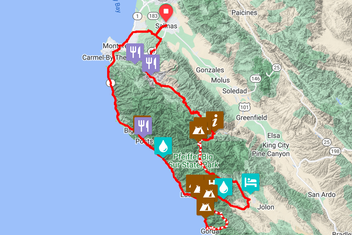
If you live near an Amtrak station on the Coastal Starlight route you could take it to Salinas, CA and start the route there. It adds about 40 miles to the route. They’re relatively easy pavement miles so the extra miles will lengthen a couple of days, but shouldn’t add a day to the trip.
Amtrak eliminates the logistics of parking a car for multiple nights. You can even book a room car with a bed and private shower. That might be good for the return trip 😉.
Coastal Starlight allows bikes and will check them with baggage. They don’t need to be boxed, but do need panniers and bags to be removed.
When to go Bikepacking in Big Sur
April through May or September through October are the best times of year to bike in Big Sur.
When the rain season begins in November, there are usually some closures due to mud slides and trail conditions can get sketchy. This year, the area saw huge rainfall and the whole region is closed through mid-March. Check for closures here.
Once summer rolls around fly season will come with it which makes for some annoying camping so best to avoid it.
I personally plan to ride one of these routes this April as long as the area is open. I’m looking forward to sharing that adventure with you in a future post!
I’d love to hear about your experiences biking in Big Sur. Leave me a comment!
All really good information, thanks for compiling and sharing!
did u end up trying one of these routes?